
Did you know that in some parts of the world, your “county” isn’t a county at all? It’s a parish. This isn’t just a quirky name change. It’s a fascinating glimpse into a rich history that shapes local identity even today.
Welcome to the world of parish maps. These unique boundaries stretch from the bayous of Louisiana to the rolling hills of England and the sunny shores of the Caribbean. They are more than just lines on a piece of paper; they are living records of culture, religion, and law.
This guide is your compass. We will navigate the historical currents that created these divisions. More importantly, we will show you how to find and understand your own parish boundaries, whether for a genealogy project, legal reasons, or pure, simple curiosity.
The Global Mosaic: Why “Parish” Instead of “County”?
The term “parish” often conjures images of a local church. And that’s exactly where it started. But its meaning evolved, diverging into two distinct paths: civil and ecclesiastical. This split explains why a place like Louisiana and the United Kingdom, though separated by an ocean, share this peculiar administrative term.
In Louisiana, the system is a direct legacy of its French and Spanish Catholic founders. Before it was a state, the territory was organized by church parishes. These religious districts were the centers of community life, so when it came time to create formal administrative zones, the name stuck. The state’s 64 parishes are a vibrant reminder of its colonial past.
Across the Atlantic, the United Kingdom tells a different story. It has both civil parishes for local government and ecclesiastical parishes for church administration. A civil parish council might manage a local park, while the ecclesiastical parish council runs the affairs of the local Anglican church. It’s a dual system that separates civic duties from religious ones.
Meanwhile, in Caribbean nations like Jamaica and Barbados, the parish system is a remnant of British colonization. These parishes function as the primary administrative divisions, much like counties in the United States, handling everything from local governance to census data.
| Feature | Louisiana Parishes | UK Civil Parishes | Caribbean Parishes |
|---|---|---|---|
| Primary Role | Main county-equivalent | Lowest tier of local gov’t | Main county-equivalent |
| Origin | French/Spanish Catholic | Anglo-Saxon (Church of England) | British Colonial |
| Total Number | 64 | Over 10,000 | 14 (Jamaica), 11 (Barbados) |
| Modern Use | Local government, courts, taxes | Community councils, local amenities | Administrative districts |
How to Read a Parish Map Like a Pro
Reading a parish map is like decoding a historical puzzle. At first glance, it’s a tangle of lines and symbols. But once you know what to look for, the story unfolds. These maps are the backbone of land titling and local identity.

Look for the dotted lines. In historical maps, these often represent the boundaries between different parishes. You might also see small icons representing churches, schools, or town halls. These are the “anchors” of the parish, the points around which the community was built.
The digital age has transformed these dusty paper records into dynamic tools. Today, we use Geographic Information Systems (GIS). These interactive maps allow you to zoom in on a specific street and see exactly where one parish ends and another begins. It’s a far cry from the hand-drawn maps of the 1800s.
3 Steps to Find Your Parish Boundaries Online
- Start with a Specialized Locator: Don’t just search Google Maps. Instead, look for your local government’s GIS portal or a diocesan “parish finder” tool.
- Enter Your Full Address: Most modern tools allow you to search by street address. This will pinpoint your location and highlight the surrounding boundary lines.
- Verify the Type: Are you looking for a civil parish or an ecclesiastical one? Make sure the tool you are using matches your specific needs.
Why Parish Maps Matter in the 21st Century
You might think these boundaries are relics of the past. You’d be wrong. Parish maps still play a crucial role in our daily lives, often in ways we don’t realize until we need to vote or pay taxes.
For genealogists, these maps are gold mines. If you’re tracing your ancestors, knowing their parish is essential. It tells you which church might hold their baptismal records or which local archive has their land deeds. It’s the key to unlocking your family’s history.
In terms of local governance, parishes often determine your school district, your voting precinct, and even your property tax rate. They are the units through which local services are delivered. Understanding your parish map means understanding how your community is managed.
Beyond the practical, there’s the emotional. People often feel a deep sense of belonging to their parish. It’s a source of community identity, a shared history that connects neighbors. Whether it’s a local festival or a community project, the parish remains a vital hub of social life.
Case Study: The Evolution of the Louisiana Parish Map
The map of Louisiana didn’t always look like it does today. When Louisiana joined the Union in 1812, it had only 25 parishes. Over the next century, that number grew to 64 as the population expanded and new communities were formed.
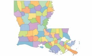
The last three parishes—Allen, Beauregard, and Jefferson Davis—weren’t created until 1912. They were carved out of the massive Calcasieu Parish. This evolution reflects the state’s growth and the shifting needs of its people.
“Louisiana is the only state to divide itself into parishes instead of counties. It’s a normal part of life here, like red beans and rice on Mondays.” — John Pope, Historical Writer
This unique system is more than just a naming convention. It’s a badge of honor for Louisianians, a symbol of their distinct cultural heritage that sets them apart from the rest of the United States.
Frequently Asked Questions
- 1. What is a parish map used for?
- Historically, parish maps were essential for land titling and church administration. Today, they are used to define local government boundaries, assist in genealogical research, and guide community planning and resource allocation.
- 2. How can I find my parish boundaries on Google Maps?
- Google Maps does not display parish boundaries by default. To find them, you should search for “[Parish Name] boundaries” or use specialized GIS tools provided by local governments or diocesan websites.
- 3. Why does Louisiana have parishes instead of counties?
- This is a legacy of Louisiana’s French and Spanish colonial history. The state was originally organized into religious districts by the Catholic Church, and these boundaries were later adopted as the primary administrative units when Louisiana became a state.
- 4. What is the difference between a civil parish and an ecclesiastical parish?
- A civil parish is a unit of local government responsible for civic duties like roads and local planning. An ecclesiastical parish is a religious district served by a specific church and its clergy. In many places, these boundaries may overlap but serve entirely different purposes.
Conclusion: More Than Just Lines on a Map
The map of parishes is a testament to the enduring power of history. From the colonial influences in Louisiana to the ancient traditions of the UK, these boundaries continue to shape how we live, govern, and identify ourselves.
Ready to explore your roots? Start by visiting your local library or searching for your county’s GIS portal today. You might be surprised by what you find hidden in the lines of your local parish map.